STURGEON BAY — The Wisconsin DNR is seeking public comments and feedback to help complete its annual listing of Lake Michigan and Lake Superior beaches.
From the DNR news release:
Following significant water level changes in 2014, DNR intensified its annual review of Great Lakes beaches and updated the listing. DNR is now encouraging feedback on the latest list, which can be found HERE
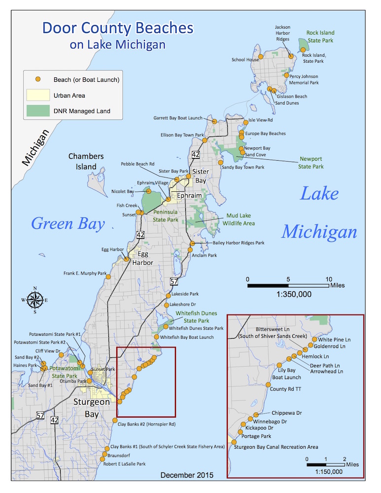
The Door County beach map is HERE and below.
To comment, contact Donalea Dinsmore, DNR Wisconsin beach program manager, 608-266-1926, Donalea.Dinsmore@wisconsin.gov; Jennifer Sereno, DNR communications, 608-770-8084, Jennifer.Sereno@wisconsin.gov
The public comment process plays an important role as beach locations, local names and conditions may change over time.
The updated maps show current beach locations for each coastal county.
Donalea Dinsmore, DNR Wisconsin beach program manager, said Great Lakes beaches provide a wide range of recreational opportunities for nearby communities while drawing visitors from other states. The beaches also serve as home to an incredible variety of plants, animals and birds.
“Our beaches contribute to our quality of life in many ways,” Dinsmore said. “Through the annual listing, we hope to bring more attention to these natural assets and identify changes for the public when conditions evolve as a result of restoration work, public land acquisition or water levels.”
Beach health efforts represent a combination of federal, state and local initiatives, including operation of the Beach Health (exit DNR) website, water monitoring and regular efforts to identify and control sources of bacteria that lead to swimming advisories. The U.S. Environmental Protection Agency requires all Wisconsin beaches along the Lake Michigan and Lake Superior shorelines to be identified and prioritized for water quality monitoring.
A “beach” is defined as any place where the public has recreational access to the water for swimming or other water-related activities. Some boat launches and natural areas are included. Inland beaches are not included in the federal program; however, several communities and state parks participate in these efforts voluntarily, posting information on the Beach Health website. These beaches are not included on the published list.
In preparing the annual beach list, DNR considers:
• whether coastal beaches should be added to the list -particularly if there are new parks with beach areas;
• water quality and whether historical data exists;
• whether conditions surrounding the beach changed ;
• how many people use the beach and how local residentsrefer to it;
• he location of the beach and the accuracy of its measurements;
• whether “Nowcasts” or other same-day tools are inplace to improve the timing for posting advisories; and
• whether the monitoring frequency is appropriate forthe use, conditions, and public notification tools in place.
To help beach-goers understand current water quality conditions at beaches, new signs will appear at beaches providing information about water quality monitoring. While existing colored signs or flags appear on the beach indicating the advisory status, the new signs include a QR code that links to the beach health website and multi-lingual messaging to explain the three levels of advice on water quality conditions.
On the signs:
Green means no water quality advisory isin effect
Yellow means elevated bacteria levels present a higher risk of illness
Red means the beach is closed.
Before heading to the beach, visitors also may want to check the Beach Health (exit DNR) website for updated information.